![[Clara and Lucy at KI Lookout Beach]](claralucyatkilookout_0258.jpg)
![[Stump Jump Plough]](stumpjumpplough_9823.jpg)
![[The view from the Cape Spencer Lighthouse]](viewfromcapespencerlighthouse_0138.jpg)
![[Emu - Inneston]](emu_9917.jpg)
Yorke Peninsula Trip
July 2005
Yorke Peninsula Trip
July 2005
The Yorke Peninsula (not to be confused with Cape York, in the far north of Queensland), is a boot-shaped peninsula across the Gulf of St. Vincent from Adelaide. On a clear day, you can see the Peninsula from Kangaroo Island (and visa versa) - so it's not far as the crow flies, perhaps 90 kilometers - but, as they say, it's a world away. It is a very popular getaway for Adelaidians who love salt water fishing, swimming and especially surfing. This time of year (remember it's winter down here) - there's hardly anyone about. And while the weather wasn't that great - we had a wonderful time exploring, and didn't get too wet - we got much wetter from the surf than the rain.
Historically, the Yorke Peninsula is known for two things - mining and agriculture. Both are still in evidence today, although agriculture is more dominant, and now the recreational aspects are coming on strong - we saw lots of new beach houses going in near the shores to add to the "shacks" (as Aussies refer to their beach houses or weekenders) already there. We explored primarily the beach-related activities, although the signs of agriculture were all around us - from the stump-jump plows on display in many places (this unique South Australian invention opened up the scrub to farming) to the flocks of sheep and fields where barley is planted in season. We had intended to explore a bit of the mining history - particularly the "Copper Triangle" in the upper west of the peninsula - but time ran out for this trip.
We started out from Adelaide on Friday morning, heading north towards Port Wakefield at the northernmost tip of the Gulf of St. Vincent. We soon left the traffic of Adelaide behind and were out into the farming country. Upon reaching Port Wakefield, we made the turn south "into" the Yorke Peninsula. We stopped at a roadside information stand to check out what they had to say, and especially the 8 blade stump jump plough on display. The unique aspect of this plough is that the individual blades are on pivots that allow the blade to jump over stumps. Why is this important? Well, the interesting thing about Mallee scrub is just how dense the bushes can be, and how many stumps with tough root systems there are in an acre of land! Without a plough that can easily till around stumps (or actually over the stumps), it takes much longer to get a piece of land into production (at least back in the days when stump removal was a hard, manual operation). The plough was perfected locally, by Clarence Smith in 1880; he built a factory in the nearby town of Ardrossan which made ploughs for the next 55 years, at the rate of up to 14 per week - the ploughs ended up all over Australia. Seeing the amount of scrub cleared on the Yorke Peninsula - and cleared of rocks as well as stumps - is pretty amazing. The fields brought back memories of New Hampshire to Tim, with occasional stone walls and big piles of stones in every paddock. What amazed us, given the density of the remaining scrub, was that there was originally any tillable land at all between stumps to make the stump jump plough worthwhile!
Interestingly, stump jump ploughs are still in use throughout Oz - nowadays, they tend to be hydraulically driven and are used to plow rocky fields - they switch between normal action (i.e., pulling straight through the soil) to stump-jumping when they meet an immovable object. Of course, with today's tractors, stronger materials, and hydraulic drive, the ploughs are capable of pulling very large rocks out of the field, making the stump-jumping action less frequently required. For some description and pictures of a modern stump jump plough, look here.
We then followed the east coast of the peninsula south to the town of Ardrossan, which has a bakery of note (why do we always head for bakeries wherever we go? Partially because Sandy is an inveterate baker - so bakeries, like quilt shops, draw attention. In addition, bakeries often have the best [or only!] takeaway food in small-town Australia.) We got mid-morning deserts (miniature apple pies for the girls, something called a "Kitchener Roll" for Tim - a sweet roll filled with berry jam and whipped cream) and took them down to the jetty to eat. Then it was onward and southward. We passed a sign "Welcome to the Bottom End!" which we thought was appropriate, after having been in the Top End a couple weeks ago (even if this "Bottom End" was only the bottom of the Yorke Peninsula, and not even the bottom of South Australia). We took the direct, sealed route to Marion Bay (stopping only for a quick picture of the beautiful St. Columba's Church in Yorketown), and saving the more scenic and unsealed coast road for another day. We rolled into Marion Bay in early afternoon, found our accommodation (at Sea Sail Cottage, a new 3 bedroom beach house a few blocks from the beach), unloaded, and then headed back to the Marion Bay Tavern for a late lunch. The views at the Tavern are very nice, and the food even better - probably the best pub-style food we've had in Oz. We marked it down to make a return visit for dinner before we left town.
After lunch, we drove down to the shore for a look around. Sandy explored the jetty while Tim and the girls explored the beach. (See also here.). After a bit of a look about, we drove further around the bay to a seaside park. As we walked up a path from the park into the dunes, we heard a loud booming sound - we were almost convinced it was thunder, as there were some pretty dark clouds in the sky - however, a little further on, we turned a corner and there was a beach with huge (well, 2 metre, anyway) waves, landing with a tremendous racket. (See also here and here.) The tide seemed pretty well in, but we explored a bit on the beach anyway, then continued our wander through the dunes, discovering interesting plants such as the Cockie's Tongue (aka Templetonia - the name of the next street over from our cottage), and taking a few pictures. Eventually we ended up back at the car and headed back to the cottage for dinner and some relaxation after a day of driving (only 300 km from Adelaide, but with our penchant for exploring here and there, it takes a while to cover distance.)
Following a restful night and a quick breakfast at the cottage on Saturday morning, we headed further south, to Innes National Park, which occupies the bottom of the Yorke Peninsula. We pulled into the visitor centre at the Park, a little before their opening time to find the ranger just putting up the Australian, South Australian and Aboriginal flags. We bought our entry pass for the day, looked at the exhibits (see here), got some advice on where to spend our time from the ranger, and headed out. The sky was somewhat grey and cloudy, but not actively raining. This time of year, the weather is always iffy, and we had watched the long-range forecast steadily worsen as our departure time in Adelaide approached - so we were quite thankful we never got a lot of rain when we were out and about, and even got occasional bits of blue sky to provide a variation in the uniform gray for some of our pictures!
We headed west along the coast (along the bottom of the "big toe" of the foot-shaped peninsula), intending to go to the western edge of the park (it was less than 20 km away), find a good beach, and explore a bit, since it was approaching low tide. We drove along, encountering a number of emus (usually in family groups - a father and several young) before reaching Dolphin Beach. This turned out to be a very nice beach - we've really gotten spoiled by Australia's beaches - miles and miles of sand, with enough cliffs and rocks and rockpools to keep it interesting - and no people around except us. The girls had a great time cruising the beach, checking out all the washed up natural treasures, and creating a spur-of-the-moment natural history museum on a rock - cuttlefish bones, various sponges, shells, seaweed - etc. (See also here, here and here.) After a pretty good exploration of the available beach, we headed back to the car, and drove further along the road to where it terminated (or actually became a walking path) at Brown's Beach. If you think of the Yorke Peninsula as a leg with the toes pointing left (west), then Brown's Beach is about at the base of the nail of the big toe - not the westernmost point, but nearly so.
There were a number of cars in the parking lot at Brown's, some having lunch as we were planning. Down on the beach were a number of surf fisherman - who didn't seem to be having much luck during the course of our lunch. After lunch, we decided to head back, since there were several other places in the park which we wanted to explore in depth before we called it a day. We stopped at a camp ground where there is also some accommodation known as the Shepherd's Hut - it looked to be just about big enough for the shepherd, but the dogs would have to sleep outside! The girls used the facilities, and afterwards we followed the sound of some galahs to a tree full of them. Then it was back on the road, and we worked our way back to the middle of the front of the big toe (passing the westernmost point at West Cape on the way), before stopping at Ethel Beach. The name Ethel comes from one of the many ships wrecked over the years in the area. This part of the Spencer Gulf and Gulf of St. Vincent around the Yorke Peninsula have not been good to shipping over the years - one of the attractions of the area is the many wrecks which are good for scuba diving. (In fact, an ironic twist is that there have been more wrecks SINCE the Cape Spencer lighthouse was installed in the late 1800s than before - largely because vessels felt safe in approaching the island housing the light for shelter from the storm - and then either driving onto the rocks under power, or having their mooring lines part and getting thrown onto the rocks by the waves!) Ethel Beach is a case in point, with at least two ships ending up literally on the beach - and one of them is still there, and occasionally uncovered by the winds to allow exploration. When we were there, parts of the wrecked Norwegian ship Ethel were sticking out - much of it has weathered away, but the form of the ship was clearing visible. In fact, it was so intriguing to Clara and Lucy that they forgot to watch the ocean - always a mistake in these waters! They were climbing about a bit of ship near the apparent water line, when one of the occasional big waves came crashing in - they saw it at the last minute, and Lucy managed her escape - but Clara got well caught and soaked to her waist. For a girl who loves the water, she didn't take it too well!
After a good exploration of Ethel beach (see also here) and the remnants of the Ethel herself, we continued our counter-clockwise journey back through the park. Next stop was "The Gap" - a hollowed-out section of cliff, similar if on a smaller scale to some of the narrow and steep inlets we saw along the Great Ocean Road, such as Loch Ard Gorge. The girls became quite concerned upon seeing all the warning signs and closed pathways where parts of the cliff had fallen in. However, we convinced them the current viewing area was unlikely to fall while we were standing on it, and they enjoyed counting the layers of rock that the water had cut through to carve the gorge. From the overlook at the Gap, you could see the Althorpe Islands, where another lighthouse stands, along with three lighthouse keepers cabins. In the far distance, we could see the bare outline of Kangaroo Island - which shares a lot of characteristics with the Yorke Peninsula.
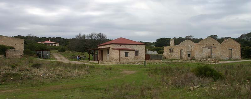
From The Gap, we turned inland, to one of the locations for early settlement of the southern Yorke Peninsula - the mining town of Inneston, which was developed in 1913 to exploit the layer of gypsum underlaying much of the area (in metre-thick veins). However, when the gypsum production moved to Stenhouse Bay in the 1960s, the town was abandoned, leaving ruins and unused mining equipment behind. The park service has started to restore some of these ruins - in particular, they've restored several of the former residences and people are allowed to rent them to stay in. We parked (once again, the only car in the parking lot) and wandered about, circling Innes Lake (while we explained what a causeway was to the girls, and how at one time there was a very light railway crossing the lake on a causeway to carry the gypsum in small ore cars (the wreckage of a couple was still laying about.) The high point for the girls was discovering a pile of gypsum, and marveling at the crystalline shapes, and how much prettier it was than the stuff that falls out of gypsum wallboard when you cut it. We found the old bakery (no roof, but brick ovens still there), and many other bits and pieces - plus a large emu family showing no fear as they grazed along in front of us.
From Inneston, we continued out to Cape Spencer, to see the lighthouse which was the source of so many shipping woes. It was on a steep and windy point of land (very reminiscent of the location of the viewing site for the Twelve [now Eleven] Apostles along the Great Ocean Road in Victoria), so we looked around for a bit, deciding not to climb down to the nearby beach. (See also here.)Instead, we continued on, stopping at the Chinaman's Hat overlook for a picture of the small island/rock formation which, if one squints enough, does perhaps resemble a coolly hat. And then it was back to the cabin for dinner and a quiet evening, listening to the intermittent rain.
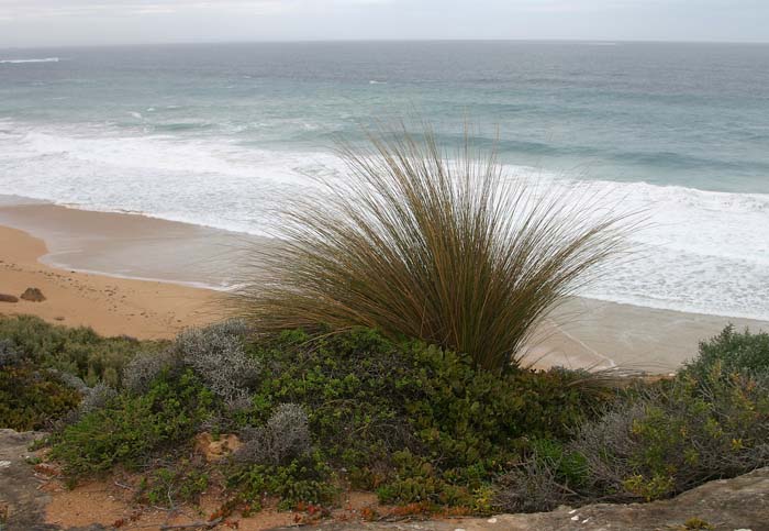
Sunday morning, we were torn in two directions, wanting to explore both the "sole" of the Yorke Peninsula boot as well as the top. We settled for a fortunate compromise, and headed east along the coast, over an unsealed track (and we were constantly amazed at the quality of the unsealed roads on the peninsula - at times, we made much better time on them than on the sealed roads!) Our first stop was at the Kangaroo Island Lookout - another spot where on a clear (or at least not too hazy day) one can make out KI in the distance. At first, we thought we'd just look - but then Tim decided the slope wasn't too steep for him and the girls - so the three of them went slip-sliding down the sandy cliff, and were soon on the beach, leaving Sandy up on top. This was mainly a rocky beach, with only intermittent bits of sand - but it was a treasure-trove for the girls. And best of all for them, it was outside the national park, and shell collecting is encouraged - so they were quite happy! They found a vein of sparkling quartz in a bed of dark rock, and happily followed its winding path around and over the other rocks. Any excuse to climb about the rocks is a good one. Meanwhile, Tim climbed on top of one of the big rockpiles, and happily took pictures of the impressive incoming waves. See also here, here, here, here and here.
After climbing back up to the top of the cliff with all the beach treasures, we headed north across the peninsula to the Spencer Gulf coast on top of the "foot." We followed 100 Line road all the way - a nearly perfectly straight, very smooth unsealed road, which ends in "The Pines", a small beach community with a Norfolk-pine-lined main drag. From there, we turned west towards Corny Point (so-named by Matthew Flinders, since it reminded him of the corn on top of a foot!) We arrived at the Corny Point Lighthouse, and proceeded to have lunch, before taking off to explore the rocky shore (with a couple of good shell beaches - in fact, the girls declared this the best shell beach ever, and were soon working on yet another natural history display on a large rock.) Once again, nothing special to report - just another fabulous bit of coastline (ho-hum!) and a good time scrabbling over rocks, examining dead creatures, collecting shells, marveling at the plastic-like shapes of many of the rocks, etc.
From Corny Point, we headed south, back towards Innes National Park. We avoided the urge to explore every little dirt track heading towards the coastline, until we got to the Gym Beach track, which we followed back to the Gulf. Gym Beach is right at the northern tip of the national park, and another nice beach (this one more sand and seaweed than rocks.) There were some pretty good waves, and some pretty soft sand, so the girls were busy avoiding the waves and getting stuck in the sand. Finally, we had to head back (detouring just a couple more times out to the coast to look along the cliffs) to the cottage for our last night.
Monday morning brought pancakes and packing, and then off we went. We decided (without telling the girls) that we would detour a bit back up to the north part of the foot, to a place named Leven Beach Conservation Park, which was supposed to have great shell-collecting possibilities. The girls were buried in their books, so didn't notice anything til we pulled into the parking lot, then wanted to know where we were. When we told them, they leapt out of the car with excitement and headed off down the beach. Tim headed in the opposite direction, and soon came back to get the girls and take them to the mounds of seaweed where he had found the best shells we had seen in a while. The girls were ecstatic, and collected several handfuls of good shells before it was time to leave. Back in the car, we headed off to Warooka, Minlaton (where we stopped for a light lunch - in the bakery, of course - and also for a picture of what appears to be the standard type of golfing green on the peninsula - a black one - we saw three separate courses with greens like this), Curramulka, and back onto the east coast road just south of Ardrossan. From there, we retraced our steps back to Port Wakefield, turned right (south), and were back in Adelaide by mid-afternoon. Another short trip finished, with more good memories to add to the store.
Pictures from our July 2005 Yorke Peninsula Trip
Click here to return to the latest journal page
Return to the home page of Tim, Sandy, Clara and Lucy
Last web page update was July 30, 2006.
Copyright © 2000-2006 - Copyright and contact details.